Blog › Where the Data in a Free Terrain Map Actually Comes From
Where the Data in a Free Terrain Map Actually Comes From
Every map is a stack of datasets wearing one coat of paint. This one stacks five, all open, and knowing what each contributes tells you exactly how far you can trust what you see.
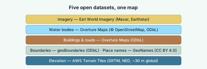
| Layer | Source | License | What it's good for |
|---|---|---|---|
| Elevation | AWS Terrain Tiles (SRTM, NED) | Open | Terrain at any scale you can hold or frame |
| Boundaries | geoBoundaries | ODbL | Region picking down to county level |
| Buildings & roads | Overture Maps (OSM-derived) | ODbL | Real heights, real street classes |
| Water bodies | Overture Maps (OSM-derived) | ODbL | Bank-shaped rivers, lakes, reservoirs |
| Imagery | Esri World Imagery | Free with attribution | The satellite look |
Elevation: AWS Terrain Tiles
The terrain itself comes from the AWS Terrain Tiles dataset — a global pyramid of elevation tiles assembled from SRTM (the space-shuttle radar mission), NED and other national elevation programs. Resolution is roughly 30 m worldwide and considerably finer in countries with national LiDAR programs.
This is the same source behind most hiking apps and GPS watches. It is excellent for terrain at the scales a person can see, and it has two honest limits: 30 m cannot resolve an individual building or rock spire, and SRTM measured the surface — treetops included — so dense forest reads slightly puffy.
Boundaries: geoBoundaries
Country, state and county outlines come from geoBoundaries' open dataset — 232 countries in the region picker, down to second-level divisions where the data exists. The picker is deliberately honest about gaps: if a country publishes no county borders, the tool says so rather than showing an empty list.
Buildings and roads: Overture Maps
When you switch buildings or roads on, footprints and street geometry come from Overture Maps — the open-data consortium project, built largely from OpenStreetMap. Buildings carry tagged or estimated heights; roads carry their class, which is how the map draws a motorway wider than a lane. Under ODbL, credited to OpenStreetMap contributors.
Rivers and lakes: Overture water bodies
Water bodies are bank-shaped polygons from Overture's base theme — rivers as their real extent, not a centreline with a guess at width. Below a certain zoom, something more interesting happens: streams too small for any global dataset are traced directly out of the elevation grid, so they follow every fold of the terrain and sit exactly on it.
Imagery: Esri World Imagery
Satellite mode composites Esri's World Imagery (Maxar, Earthstar Geographics) into the terrain texture — the same mosaic most web maps use, also the reason the satellite default of Manhattan looks like a photograph.
The part that matters: none of it touches a server of ours
Every one of those sources is fetched straight to your browser, decoded and rendered locally. There is no account to make because there is no server side to make one on — your region, annotations and exports never leave your machine. Try any region to see the stack assembled; the legend credits every layer in the current view.
Try it while it's fresh
The whole tool runs in your browser — pick a region, shape the relief, export. No account, nothing to install.
Open the terrain app