Blog › Turn a GPX Route into a 3D Map You Can Share
Turn a GPX Route into a 3D Map You Can Share
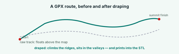
A GPS file is a good record and a bad story: a spreadsheet of coordinates that only means something when you put it back on the terrain it crossed. That draping — the route line settling onto the real mountains — is the whole trick, and it takes one click.
Drape the route
Export the GPX (or KML) from Strava, Komoot, Garmin Connect or Wikiloc. In the terrain app, pick a region that contains the route — a named area or a drawn box — and press Import GPS track. The line is resampled to a clean arc and laid onto the elevation grid, so it climbs the ridge and drops into the valley the way the day actually went.
Style the ground under it: satellite imagery, any of the colour ramps, real-width rivers, buildings if you rode through a city. Then annotate the parts that matter — a numbered marker at the café stop, an arrow across the descent, a text box with the date and who was there.
Three things to do with it
The picture. Export at 2× for a race report, 4× for print. Title, legend, scale bar and data credits are composited into the image, so it's presentation-ready straight out of the menu.
The clip. A 30-second MP4 orbit of the scene. Turn on the auto turntable first if you want the camera to swing around the summit rather than hover. This is the one that does numbers on club socials.
The print. Export the STL and the route becomes a raised line on the terrain, so the print carries the line with it — setup guide.
A second import, a different job
There's a separate button, Add GPX as annotation, which pins a simplified route line onto the map face instead of draping it in 3D. Use it when you want the route as a graphic on a flat map export; use Import GPS track when you want the terrain to be the story.
Sharing
Share Link produces a short URL that reopens the exact scene — region, palette, camera angle, the route and every annotation. It doesn't expire, and if it's your link you can update the contents later without changing the URL. Race reports and route pages love this: embed the link instead of screenshots, and readers get the 3D view itself.
Try it while it's fresh
The whole tool runs in your browser — pick a region, shape the relief, export. No account, nothing to install.
Open the terrain app